
 |
 |
||
| Part I | Part II |
Miles, Bill Sornson (Sorni), Morgan, Bill
Porter (MTB Bill) and myself all decided to make the trek from San Diego up to
the San Bernardino Mountains and do this ride that we've all heard about but had
never ridden before. We followed the basic directions found on the trail review
sections of
MTBR.com and
SoCalMTB.com
to get there and complete the ride so there weren't any surprises on the way up
there.
We got to the trailhead which is over 5,000 feet and were welcomed to an
absolutely gorgeous day. The sun was out but it wasn't super hot. With the
trees we would soon be riding through providing shade, we figured that it would
get a bit warm but wouldn't be too uncomfortable a day for a long ride.
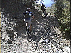
We knew from the trail reviews that you could either head straight down the
fireroad at the end of the parking lot ior backtrack just a bit on the paved
road to hit a single-track descent. Obviously we took the single-track and were
blessed with an absolutely fantastic ride just minutes from the car. This
single-track is almost entirely downhill with only short uphill sections and
it's this way for 3 miles!
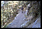
Overall the trail wasn't very difficult but it was narrow and in most sections
there was always a rather steep drop to one side or the other. There were a few
sections that caused a bit of pucker though because about 12 inches from your
tire there was a vertical drop of anywhere between 10 and 30 feet so that made
things interesting. You can see one section of trail like this at about 4:40 of
the first video but the camera really doesn't do justice to the severity of the
drop.
We knew from looking at some trail reviews that this was an out and back and
that the ride out was generally uphill but with lots of rolling ups and downs.
I can honestly say that because most of my altitude training occurs at about 200
feet above sea level, ANY climb was noticeable but after about 30 minutes or so
I got used to the elevation a little. We took the trail from the town of
Angeles Oaks all the way to South Fork Campground which was just over 17 miles
one way. Morgan took a bit of a break about 4 miles from South Fork and we
picked him up on the return trip after about an hour. The trip back was a blast
because it was mostly downhill but the riding was still quite difficult.
Because of the rolling nature of the trail you would descend a bit but have to
scrub off speed because of a sharp turn with a serious penalty for failure. You
then would have to power up a short 20 or 30 foot climb which really started to
take it's toll on all of us. We made it to the bottom of the fireroad for the
climb out and on any other day the climb would have been a piece of cake.
However, at the 28 mile mark of a very long day at elevation this climb just
sucked! It was a perfectly grated road with a very shallow rate of ascent so
you just had to suck it up and spin your way to the top but boy was I glad to
see the parking lot.
All told we did 31.5 miles and although the net elevation gain from start to
middle (this is an out and back trail) was only 1500 feet we did a total of
5,900 feet of climbing. We stopped in Redlands for a quick post-ride Burrito (I
sure do love Southern California for the abundance of Taco Shops!) and headed
home. Because the ride isn't right next door, it won't be a frequent ride in
our arsenal but it will definitely be on our list of rides to do again.